Main page content begins here

Bike route maps and information on how to navigate the Downtown, Southside and West Central bike routes.

These maps and routes help you pre-plan your bicycle trip. The maps include major destinations such as parks, leisure centres and attractions.

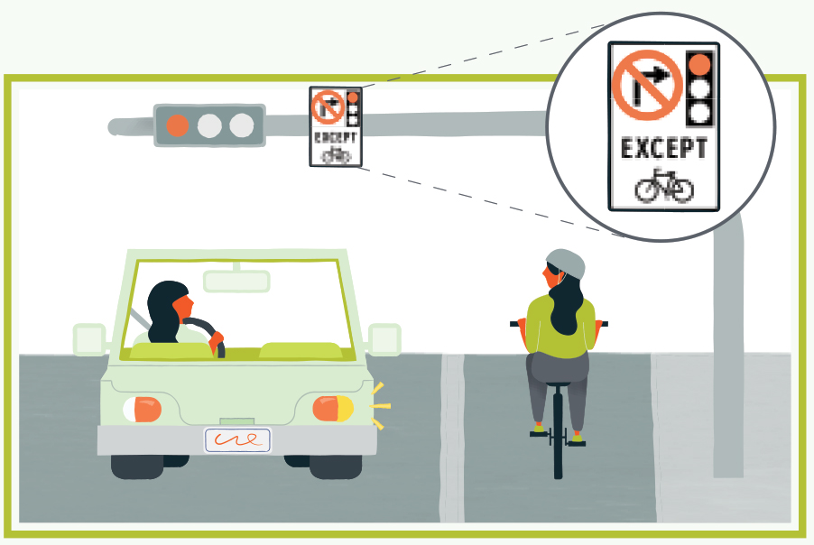
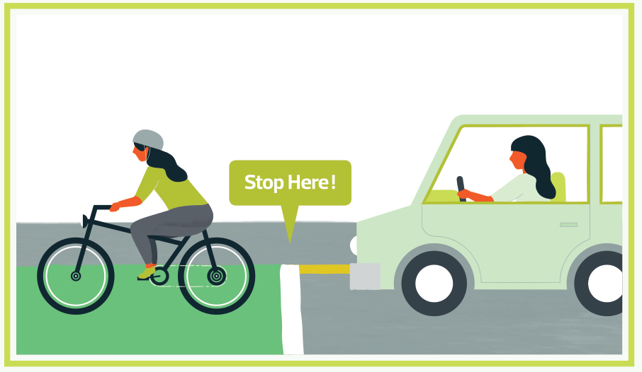
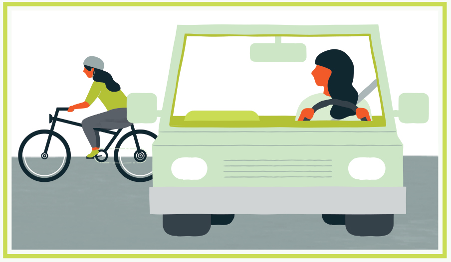
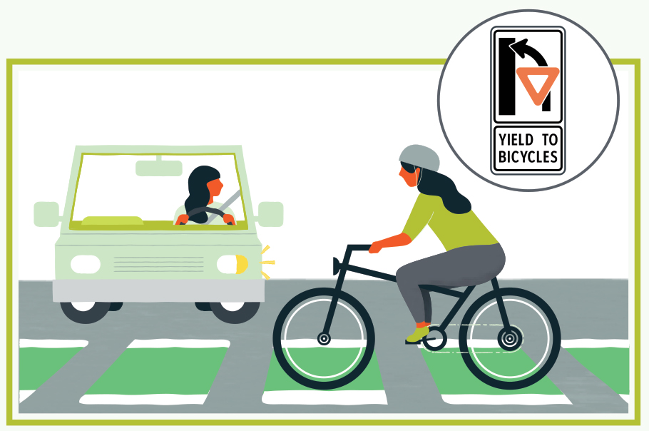
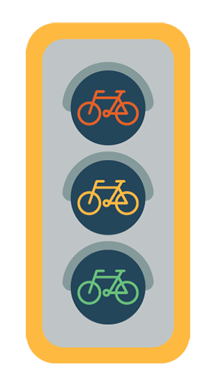
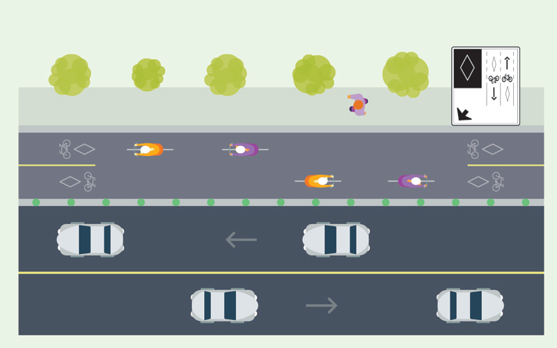
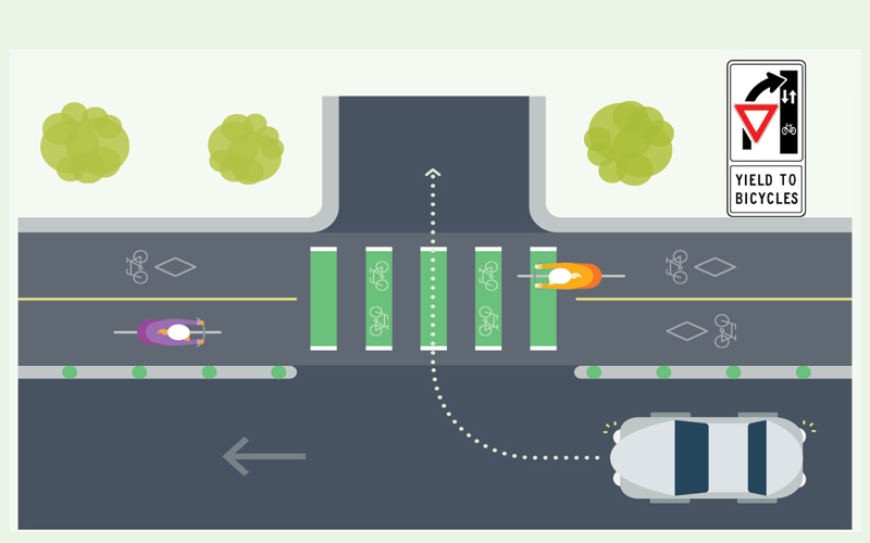
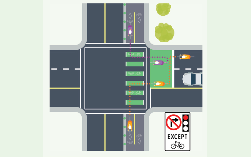
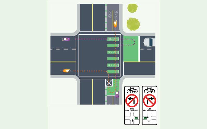
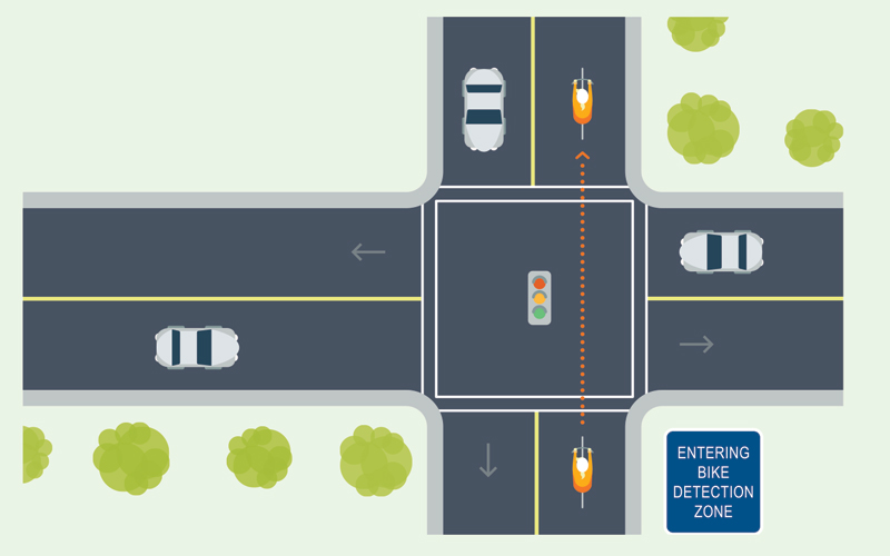
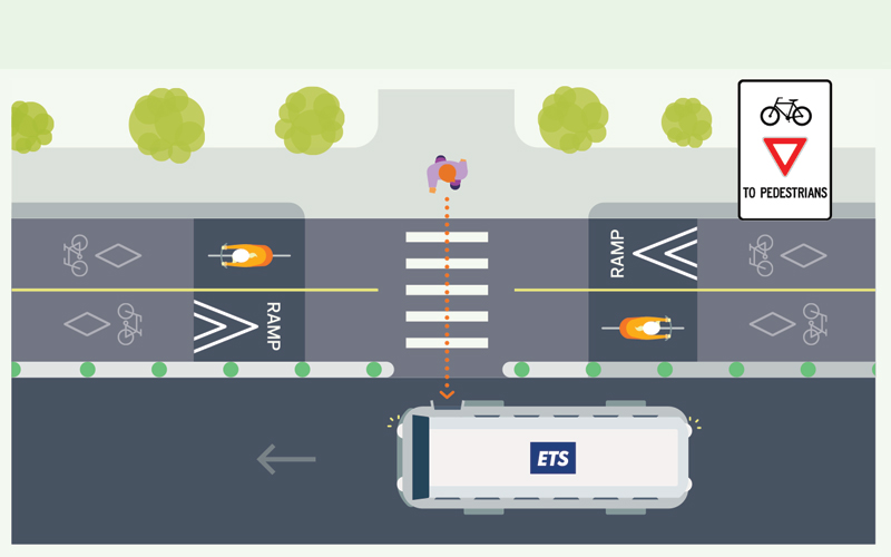
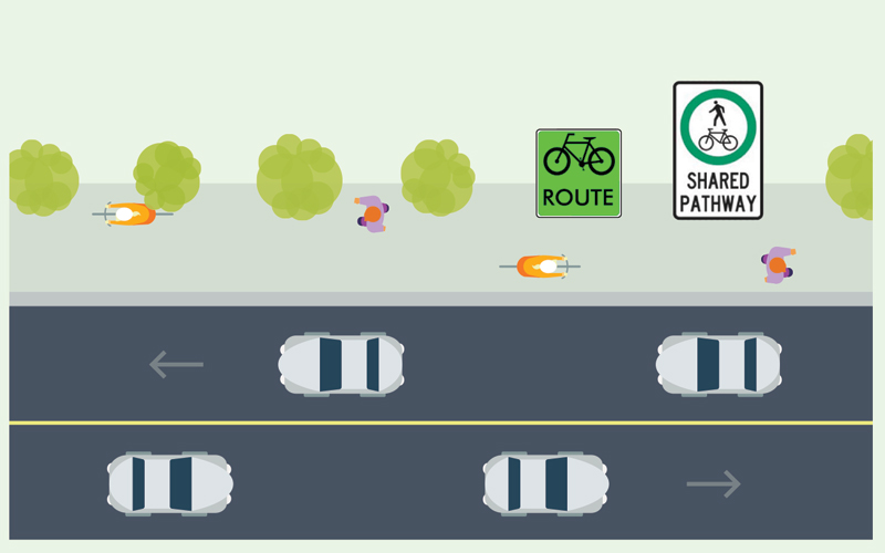
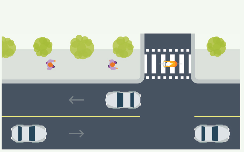
While riding, look for traffic signs and road markings that will help you navigate your route. Always be prepared to change course based on the current road and traffic conditions.

Discover YEG Map

Use the interactive and mobile friendly map to discover the bike routes and river valley parks citywide

Edmonton Bicycle Map (20MB)

Detailed map showing Edmonton's Bike Network, including Downtown and Strathcona bike routes.

Includes destinations, attractions, points of interest and a listing of bike stores, clubs and organizations.

PDF Route Maps

Edmonton Bicycle Map (20MB)
View the downtown and Strathcona bike networks.

Downtown Bike Network Map
View the routes that make up Edmonton's downtown bike network.

Southside Bike Network Map
View the routes that make up Edmonton's southside bike network.

West Central Bike Network Map
View the routes that make up Edmonton's west central bike network.

Interim Report

Report cover showing illustration depicting a cyclist.
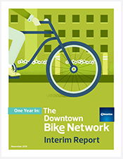
Learn more about the first year of the operation of the downtown bike routes in our interim report (24MB).

Downtown Bike Routes

Edmonton’s new adaptable Downtown Bike Network offers over 7.8 km of protected bike lanes, shared roadways, and paths to help and inspire Edmontonians of all ages to try new ways travelling to get around Downtown.

Map Legend

Future Protected Bike Lane  Future Protected Bike Lane

Painted Bike Lanes  Painted Bike Lanes

Protected Bike Lanes  Protected Bike Lanes

Shared Roadways Lower Traffic  Shared Roadways (Lower Traffic)

Shared-Use Path  Shared Pathway

Under Review  Under Review

Southside Bike Routes

Over 4.4 km of protected bike lanes, shared roadways, and paths have been installed to support and inspire Edmontonians of all ages to try new ways to get around in their communities and in the city.

Map Legend

Painted Bike Lanes  Painted Bike Lanes

Protected Bike Lanes  Protected Bike Lanes (2 and 1 way)

Shared Roadways Lower Traffic  Shared Roadways (Lower-Traffic)

Shared-Use Path  Shared Pathway

Under Review  Future Route Extension

West Central Bike Routes

Over 4.2 km of new protected bike lanes, shared roadways and paths have been installed in West Central Edmonton to support and inspire Edmontonians of all ages to try new ways to get around in their communities and in the city.

Map Legend

Painted Bike Lanes  Painted Bike Lanes

Protected Bike Lanes  Protected Bike Lanes

Shared Roadways Lower Traffic  Shared Roadways (Lower and High Traffic)

Shared-Use Path  Shared Pathway

4 Things to Know - In Your Car

1. Watch for no right on red signs

Watch for no right on red signs

An important new sign on the bike lanes is the “No Right Turn on a Red.”

  • Cars are not permitted to turn right across a bike lane on a red light
  • Cyclists can turn right on red lights at these intersections
2. Don't stop on green paint

Don't stop on the green paint

Green paint indicates points on the road where drivers and cyclists might cross paths.

  • Avoid stopping on the green paint
  • Stop behind the white line of the bike box
  • Watch for cyclists wherever you see green
3. Shoulder check and look both ways

Shoulder Check and look both ways

Cyclists will be traveling quickly and coming from both directions in the bike lanes.

  • Watch for cyclists in the bike lanes and on the roads
  • Shoulder check and look both ways for cyclists before turning across a bike lane
4. Yield to cyclists when turning across the bike lanes

Yield to cyclists when turning across bike lanes

Green Stripes or White Dashed Paint indicates that a bike lane is crossing an intersection or accessway such as an alleyway or entrance into a parking lot.

  • Look both directions and shoulder check before crossing the bike lane
  • Yield to cyclists in the bike lane and pedestrians in the crosswalk
  • Do not block the bike lane

How to Use Bike Routes

Bicycle Signals

Bicycle Signals illustration

Bicycle Signals will be located throughout the Downtown Bike Network. Refer to these signals when crossing intersections. Signal timings may be adjusted as the Downtown Bike Network evolves.

In your car and on your bike:
  • Watch for signs indicating signal phase changes
Protected Bike Lanes

Bike Network - Protected Bike lanes

Protected bike lanes are on-street bike facilities protected from moving and parked cars by a physical barrier. These lanes make driving and cycling more comfortable by creating a dedicated space on the road for people to bike. Protected bike lanes may allow for travel in one or both directions.

On Your Bike:
  • Watch for signs and paint symbols indicating the direction of travel
In Your Car:
  • Look both directions and yield to bikes when crossing
In Your Car and on Your Bike:
  • Travel slow along the Downtown Bike Network so you have time to see and respond to all the new features
Green Stripes at Intersections

Bike Network - Green Stripes at Intersections

Striped green paint indicates that a bike lane is crossing an intersection or accessway such as an alleyway or entrance into a parking lot.

On Your Bike:
  • Look both directions when crossing
In Your Car:
  • Look both directions when crossing
  • Yield to cyclists in the bike lanes and pedestrians on the sidewalk
  • Do not block the bike lane
  • Watch out for the new signs indicating changes to turning rules
Bike Box

Bike Network - Bike Box

Green Bike Boxes painted in a driving lane allow cyclists to do two things:

  • Pull in front of waiting traffic at a signalized intersection, making cyclists more visible and giving them a head start when turning or going straight
  • Make safe turns by using it as a Bike Turn Box

If the Light is Red

On Your Bike:
  • Enter the Bike Box and position yourself in your direction of travel
  • When the light turns green, proceed as normal
In Your Car:
  • Stop behind the white line
  • When the light turns green, proceed as normal

If the Light Is Green

On Your Bike:
  • To turn left: Yield to cars, then move into the Bike Box when safe to do so
  • To go straight or turn right: Proceed as normal
In Your Car:
  • Proceed as normal

Videos

Bike Box Video: Turning Left on a Red

Bike Box Video: Turning Right on a Red

Bike Box Video: Turning Left on a Green

Bike Turn Boxes

Bike Network - Bike Turn Box

Green Bike Turn Boxes painted at intersections provide cyclists with a safe way to turn left or right. These boxes can be found in the bike lane or in a driving lane.

On Your Bike:
  • Move into the green box found either in a bike lane or driving lane
  • Position yourself in your new direction of travel and wait at the red light
  • When the light turns green, proceed through the intersection
In Your Car:
  • Do not stop in a green Bike Box
  • When the light is red, stop at the painted white line behind the Bike Box
In Your Car and on Your Bike:
  • When stopped at an intersection, do not stop on the "X"

Videos

Note: Crossing two lanes of traffic to make a left or right turn from a protected bike lane is not permitted.

Bike Turn Box Video - Turning Left

Bike Turn Box Video - Turning Right

Bike Triggered Crossing - Signal with Sensors

Bike Network - Bike Triggered Crossing

Bike-triggered crossings help cyclists to cross at intersections.

On Your Bike:
  • Watch for the “Entering Bike Detection Zone” sign
  • Once you pass this sign, stop and wait; you will be detected by the sensors
  • Cross when the pedestrian light turns white
In Your Car:
  • Be aware of bikes crossing the intersection
Raised Crossing at Bus Stop

Bike Network - Raised Crossing at Bus Stops

A Raised Crossing brings the level of the roadway to that of the adjacent bus stop. Transit users will be getting on and off the bus at this location.

On Your Bike:
  • Slow down and yield to pedestrians
On Your Feet:
  • Be aware and look both ways before crossing
  • Do not wait/stand in the crossing
Shared Pathways

Bike Network - Shared-Use Paths

Shared pathways are for many activities. You can bike, walk, run and more. Some sidewalks may be designated as Shared Pathways. Watch for signs.

On Your Bike:
  • Use the path to travel in both directions
  • Ring your bell to pass
  • Slow down and pass on the left
  • Yield to slower users
On Your Feet:
  • Keep to the right
  • Be aware that others may choose to pass you on your left
In Your Car:
  • Check both directions and should check for bikes when crossing a shared pathway
White Squares at Crosswalks - Shared Bicycle and Pedestrian Crossings

White Squares at Crosswalks - Shared Bicycle and Pedestrian Crossings

When a Shared Pathway crosses an intersection, the crosswalk will be lined with White Squares. These squares identify shared bicycle and pedestrian crossings and may be controlled by a pedestrian walk light and traffic signal.

On Your Bike:
  • There is no need to dismount your bike to cross
  • At a crosswalk with a pedestrian light: cross when the walk light is on
  • At a crosswalk without a pedestrian light: yield to cars and pedestrians before entering the roadway and cross when it’s safe to do so
In Your Car:
  • Be aware that people on bikes may be riding across the intersection

Network Adaptability

The Downtown Bike Network is adaptable to respond to major shifts in traffic and infrastructure.

As projects are completed, like the Valley Line LRT and ICE District, the City has the ability to adjust the network.

Evaluation and monitoring of the Downtown Bike Network will be ongoing and adjustments will be made as needed to ensure the network stays a safe and accessible transportation option, while minimizing impacts on other modes of transportation.

There will be an evaluation period to determine how the network is operating before any potential changes are considered.

Evaluation and Performance Monitoring

We have partnered with the University of Alberta to develop a performance monitoring framework for the Downtown Bike Network.

The following tasks will be completed as part of this work:

  • Measure the connectivity of the current bicycle network and the proposed bike network
  • Develop an overall evaluation framework for the purpose of monitoring network performance over time
  • Monitor network performance before and after installation of the Downtown Bike Network 

As a part of the evaluation of the Downtown Bike Network, bicycle, pedestrian and vehicle traffic counts are being monitored with single day counts at 13 locations along the new bike lanes. These counts are taking place approximately every 2 weeks to retrieve examples from weekdays, the weekend, holidays and event days. This data will be crucial for planning and managing cycling infrastructure.

Winter Maintenance

Maintaining and clearing the Downtown Bike Network will be crucial in ensuring it stays an accessible and safe route for everyone. The width of the protected bike lanes allow room for most City maintenance equipment to clean the network in the spring, summer, and fall.

During the winter, the Downtown Bike Network will have dedicated crews to provide snow and ice control. Road maintenance activities that will be involved in maintaining a clear bike lane will include sweeping, removing snow from buffer areas and clearing snow from adjacent sidewalks. The Downtown Bike Network is part of the City’s primary bike network the City will make best efforts to plow and remove snow within 24 hours after the end of a snowfall.

End of page content. Please choose between the following five options:

Back to main menu Back to current page menu and content View current page breadcrumb Back to site search Continue to page footer content